Odd photos on my way to work

Yesterday as I was walking to my office from Waterloo I saw this lady (or is it a man?). Now I’m no great follower of fashion, but…
Crazy clothes lady 2 Crazy clothes lady 2

Then this morning on the roundabout just by Waterloo a fire engine had toppled over.
Toppled Fire Engine
It might’ve been my physics teacher who told us that fire engines have an extra stability problem created by the water sloshing around in their tanks. Modern fire engines have perforated plates called “baffles” fitted inside their tanks to reduce this effect. In this case though, it wasn’t a normal fire engine it was some kind of fire equipment truck. Anyhow they were obviously taking the roundabout a bit too quickly! So I took this snap and sent it to the BBC. To my surprise they phoned me back a minute later to check if it was OK to use it. So here’s my photo on the BBC site. Only made it onto the ‘extra’ photos section, but I’m surprised they were interested in it at all. It’s not actually a very good photo.

The joy of spring …poo

Apparently spring starts next weekend, but it felt pretty springy today. We dusted off the roller-blades and headed to Hyde Park. Perfect weather for it.

Just now I also ventured into the garden and had a good look at it for the first time in months. As I prepared to give the lawn a trim I discovered it was absolutely full of evenly spaced piles poo from the neighbours’ cat. Hadn’t noticed this during my dark winter trips to the compost bin, but no doubt trod in them a few times!

All cleared up now and the lawn is looking glorious.

Post Poo Lawn
…hmmm well as glorious as it ever does using a strimmer.

.

Skating round Wembley stadium

Last Sunday I spent the whole day roller-blading around the streets of Wembley. I managed to get a sun tan (in October!) and it was the most exercise I’ve done in a long time. It’s taken about a week for my legs to stop aching.

It was the Wembley Mapping Party, a gathering of OpenStreetMap enthusiasts who were surveying the streets gathering street names, pubs, bus stops, post boxes, and other such details to go on a map.

Here’s my GPS trace

Wembley Screenshot of JOSM

Notice the interesting circular loopy bit. That’s Wembley Stadium!  I was also on personal mission to bag another stadium. I skated in a loop around the base of the building to get this GPS trace which I could then use to map it out reasonably accurately. OpenStreetMap did already have it, but the outline was drawn around yahoo aerial imagery which was out-of-date, showing the smaller previous stadium before it was rebuilt. The more circular footprint of the modern stadium should be showing up soon on openstreetmap (here)

This was a fun loop to draw by GPS, but most of the time the process of mapping out London is a bit more straightforward. We can rely on Yahoo! Aerial Imagery to give us a road layout, and so it’s mainly a matter of collecting street names (eliminating the orange unnamed streets) Anyone can get involved in that. It’s not too complicated. Create an account and try editing!

London Bloggers Meet-up

I suppose I really have to blog about going along to the London Bloggers Meet-up last night. It would be rude not to.

It was held at the Dogetts Coat & Badge, which is a favourite of mine actually (We’ve taken my girlfriend’s Brazilian visitors to this pub for traditional english grub, and views over the Thames) . Last night the beer in the upstairs function room was flowing free (thanks stella) .

I think there’s quite a few competing meet-up events for “bloggers” in London. This is the first time I’ve been to one, partly because I wasn’t sure if I could really call myself a blogger. I’ve been properly blogging on harrywood.co.uk for eight months now though, so yes, I suppose I am now officially a blogger.  ….but still more of a “wikier” perhaps. 

So who are these London bloggers? This is something I had been wondering. Obviously anyone and everyone can be a blogger. It’s easy, and very mainstream these days. People from all walks of life. Female and male. Old and young. There was some evidence of this in the room, but of course there was still a heavy bias towards the usual IT demographic. 25-35 year old males. I’m sure blogging itself still has this bias, despite being increasingly mainstream. But also this was a meet-up of those bloggers who are keen enough about blogging itself (rather than just being keen on non-tech topics they blog about) to come along to a blogging meet-up, which I guess makes it more of a tech meet-up. Even so, it wasn’t a purely geeky gathering, which is good.

At the other extreme perhaps,  are the people who actually do jobs relating to blogging. Social media agencies, Web2.0 consultants, whatever you want to label them. Some people talked about PR type roles. I was surprised by the number of these people there seemed to be. Of course it isn’t surprising that such people would choose to come along to a London bloggers event, but I guess it’s surprising to come face-to-face with a fledgling industry which is emerging out of something as fun and chaotic as blogs

Anyway…. enough of this blogging about blogging
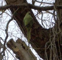
Sunshine, BBQ, Monopoly and Wikipedia Meet-up

Me Winning Monopoly
Stinking hot weather in London at the moment, so the BBQ came out on Saturday, and so did the hammock! Francine and the brazillian ladies came round, and I tried out my caipirinha making skills with my wooden lime crushing thingy.

In the evening we played monopoly, and I won! (the first time I’ve won monopoly in a long time) I kind of felt bad about beating them because they were all new to the game, or hadn’t played it as many times as me, so I should’ve let one of them win really. They probably thought I had beaten them easily with my superior monopoly playing tactical experience, but no! I’ve never been convinced that this game involves much skill/tactics at all. I just happened to be more lucky this time.

Sunday was also very hot, so I put on my shorts and sandles as I headed out to the 9th London Wikipedia Meet-up. Unfortunately the Penderel’s Oak pub is not so great for sunlight, although we did at least have a view onto the insanely sunny street. It was another successful meet-up. Having nominated myself as cheif promoter (and talk page spammer) I was pleased to see a reasonable turn out. Gordo was doing his Three Mills Loop walk again, so he didn’t make it. Looks like they made the most of the sunshine

Mapping the Three Mills Loop

The weekend before last we went on an organised walk and talk called Three Mills Loop around Bow in East London. It was organised by Gordon Joly, who is someone I meet up with at wiki gatherings. He’s a prolific photographer of random bits and bobs around London, as indicated by his flickr photostream which literally streams a constant flow of new photos appearing on my ‘friends photos’ display. But while he was guiding us and talking about some of the sites on the walk, I thought I’d out-photo him on this occasion. I took 274 photos around the route! They were mostly exceedingly uninteresting though, because I was actually doing some photo mapping, so it was pictures of street signs, pubs, post boxes and other mappable things. In the openstreetmap software I can lay out the photos along my GPS trace.

Three Mills Loop photos in JOSM
click to enlarge

That’s what it looks like alongside the nodes and ways of the openstreetmap data (shown here as a deselected layer in faint grey). The openstreetmap data can be modified in this JOSM software. I was able to develop the coverage, adding new street names etc which were missing from the map before. My contributions now appear on the map of the area

A recently added feature of openstreetmap is the ‘Export’ tab, which allows export to SVG format. This means you can play around with a vector representation of a map, with full power and flexibility to craft your own image. I tried this for creating map images for wikipedia articles. This walk presented another opportunity to give this a try. Here’s a map illustrating the route of the Three Mills Loop walk:

Three Mills Loop Map

This map image isn’t just a yellow line overlaid on top of an OpenStreetMap image. I’ve customised the map graphic (using inkscape) to tidy it up. I corrected some of the rendering quirks, including moving some street names, removing extraneous one-way arrows and A/B road markers. I’ve also made the area around Bromley-by-Bow station much clearer, including pedestrian underpasses, to make it easier to find the House Mill meeting place:

House Mill Access

This has been made possible by the recently added ‘Export’ tab feature of OpenStreetMap. Try doing that with google maps!

The walk route took us past some pleasant canal scenery, and we passed right through the Olympic construction zone. It turned out that the extents of this needed to be updated on the map (although it no doubt still needs some further corrections). This was an interesting sight to see, as was the old Victorian Abbey Mills pumping station.

Trafalgar Square Hawk

Trafalgar Square Hawk
On Sunday we went on a walk through several parks, but at our start point, before we even got to any parks, we had another interesting ornithological encounter. In amongst the usual tourist crowds I noticed a big brown bird of prey swooping onto a perching spot in one corner. The hawk then flew past my head back to his owner, a guy standing by Nelson’s column. I hadn’t noticed until then, but there were no pigeons. Not a single one!

I must have missed the news, that the authorities have deployed this hawk as a pest control technique. Awesome. It’s amazing how effective it seems to be. We saw one or two pigeons flying very high up, and veering away from the square. Apart from that, nothing.

I notice the idea has its critics, and the enevitable save the pigeons campaign group. They call it “bloodsport”. I didn’t see any blood, because there were no pigeons! They’re obviously all scared shitless of it. Interestingly that website also claims that pigeons do not pose a disease problem. I think they’re probably right about that. How many people d’you hear about catching diseases from pigeons? But I’m not a fan of pigeons. There’s too many of them. They crap everywhere, and they’re just boring.

Hawks on the other hand…. kick ass!

Underground under Camden

Underground railway junction near CamdenTo settle an argument I’ve been having for ages, I was looking for a diagram which illustrates what happens to the Northern line at Camden Town. The tube map doesn’t show the details. Wikipedia’s Northern Line article has schematic strip diagram (down the right), which shows where the junction is [UPDATE: since then the wikipedia Camden Town article also has a more detailed diagram on the right]

This prompted a whole fresh bout of web surfing around [useful/strange modifications to the tube map] (owen.massey.net/tubemaps.html is a broken link now). (hmmm I need to suggest a new addition. The OpenStreetMap tube map is the only truly open licensed tube map)

But ultimately the most comprehensive diagram of what really happens below the streets of Camden, came from asking the tube enthusiasts on wikipedia. Actually all the underground diagrams on this very old ‘see how they run’ website (an archived copy of an old geocities website!) …are interesting for Londoners to puzzle over. It’s weird how you can go through that kind of underground train junction every day, and not really have any understanding of its layout.