British Computer Society Talk

Yesterday I gave a talk to the British Computer Society about openstreetmap.

OpenStreetMap talk on slideshare.com

Audio mp3 (68 MB)

Download the slides : BCS-OSM-talk.odp (34.2Mb)

The topics I talked about were

  • OpenStreetMap purpose and premise – Comparison with wikipedia, graph showing the long tail nature of the community
  • Data structures – Nodes, Ways ,Tags and their XML representations
  • Editor demo – Quick demo of adding a road and a POI in JOSM
  • OpenStreetMap servers and architecture – Component diagram, UCL hosting details, and the OpenStreetMap foundation
  • Rendering and map displays – OpenLayers, Tile serving/hosting challenge, Mapnik toolchains, and other renderers
  • The license – Attribution. Sharealike. The spirit of the license, and change to the Open Data Commons

That was all well received. Of course OpenStreetMap is a topic I have tonnes to say about, and I as prepared I got a bit carried away, and came up with 146 information packed slides. I had quite a long time to talk, but what with JOSM demonstrations and video interlude, it was clear I’d overrun by a mile, so I stopped at a convenient juncture part way through.

I intended to spend a lot more time talking about CloudMade products and services, particularly the styles and style editor at maps.cloudmade.com and the developer zone.

Other topics I didn’t cover include: Imports, Yahoo imagery, Landsat & NPE, Armchair mapping, a demonstration of photo mapping in JOSM, Mapping Parties, Developer community, and details of how to get involved. Enough material for a part II some time perhaps!

State Of The Map 2009 – signed up

sotm-banner-text.png

I just signed up for the State Of The Map conference for 2009. If it’s anything like last year it’ll be a fun-filled map fest, but actually I predict it will be even better. The OpenStreetMap community is getting pretty massive nowadays (100,000 users), and it seems like clever new uses of OSM data are springing up on a daily basis, so the conference should be pretty amazing. But also it’s in the middle of Amsterdam. Awesome location! It’s going to be really fun to go there and meet hundreds of other OpenStreetMap enthusiasts.

Cloudmade launch event

We had our big Cloudmade launch event on Thursday. All the key people at cloudmade have been very heavily focussed on preparation for this for some time now, and it seemed to pay off. The guys did a great job with slick professional talks getting across our message, that the openstreetmap project is opening up exciting new opportunities for mapping and location-based services, above and beyond anything that google maps could ever offer, and that cloudmade’s products and services help to bring that power to your applications.

They’ll be more product release announcements like this one on the cloudmade blog, over the coming months, which will no doubt generate even more buzz.

My job for the evening was to man a demo station. Answering people’s questions about openstreetmap and cloudmade, with a big plasma screen behind me. This turned out to be really quite fun.

These photos and many more great pictures taken by Christian Petersen at the event. Afterwards we had a little after-show party, which got a bit more messy.

Got home at 4a.m. although that was after an accidental visit to end of the 134 bus route

Kayaking, Mapping, and Accidental GeoCaching

Another great weekend of kayaking. We’ve had some evil cold spells recently but happily last weekend we had a some fluffy warm rain clouds over North Wales. As detailed on the trip report , and Adam’s blog, we paddled the Dwyfor on Saturday, and the Wnion on Sunday. Both completely new rivers, except that I do remember paddling the easy bit at the bottom of the Wnion before. The Grade 4 bit coming before that was a pretty awesome highlight of the trip.

Now I had planned to do some whitewater mapping on this trip. I did get GPS tracks on the rivers. This is good for mapping out the waterway=river position more accurately than it was before (traced from low-detail out-of-copyright maps)  And the track looks very pretty shown against the green landsat imagery of the welsh countryside:

Afon Dwyfor trace

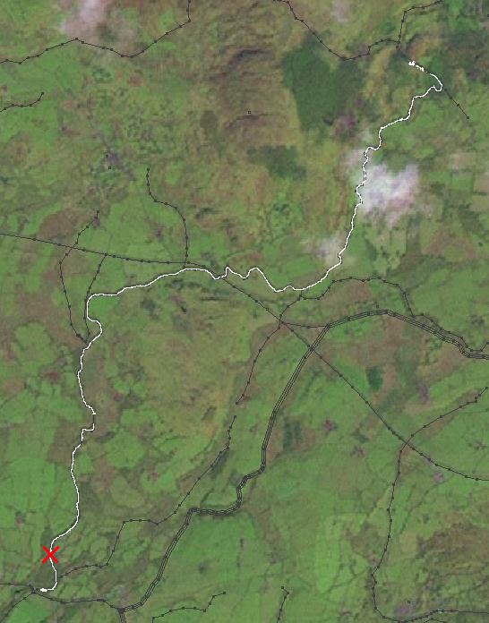
And I had also been taking lots of photos to remind me of whitewater grades and other details for the map such as footbridges and power lines which we’d passed underneath, but unfortunately ‘X’ marks the spot where I dropped my digital camera in the river and lost it!

Accidental GeoCache – Pentax Optio W30

It is a waterproof camera.  I dropped it into the river at latitude:52.9394149 longitude:-4.2483416 (well actually about 10 metres upstream from there)   I know this because after spending about 10 minutes wading around in the current trying to find it, I recorded a waypoint on my GPS. I thought maybe it might make an interesting accidental geocache for somebody.

That’s right! If you want a fully functioning Pentax Optio W30 waterproof digital camera, head to those coordinates. However you might need some waders and a metal detector! If you do manage to find the camera I’ll be so impressed I’ll post the battery charger and USB cable to you! …so there’s a challenge

Only trouble is, I notice on the description there it’s only supposed be waterproof for up to 3 hours. My poor camera has been languishing on the river bed for 2 days already. How long before somebody rescues it?!

I bought that camera seven months ago , so not really a very good innings. It’s annoying to have lost it for such a stupid reason. I had it tied to me, but the crappy bit of string was too fat, and the knot evidently untied itself.

But in truth the Pentax Optio w30 is a pretty pants camera. Not a very smart purchase. It was starting to annoy me. I had decided to go for a waterproof one, without testing one in the shop first, thinking surely all compact digital cameras are much-of-a-muchness these days.  At first I was terrified of submerging it because it really doesn’t look waterproof, but actually the waterproofness was fine.  For general use though, it took way too long to switch on and be ready for taking a photo, and it took about an hour to focus in the dark.

Joining CloudMade

CloudMade logoI’ve just had my first week at my new job working for cloudmade. OpenStreetMap has progressed from being an interest, and then a hobby, and then an obsession. Now OpenStreetMap is my job. Maybe that makes me one of those annoying smug people doing the job of their dreams.

But lets not get carried away now. There’s lots of work to be done. I’m going to need to learn the ropes of proper OpenStreetMap coding. No more skulking in the side-lines fiddling with the OpenStreetMap wiki (well OK I’ll still be doing a fair bit of that)

I’m in the process of learning Ruby on Rails, a super-modern agile web development language the likes of which my old “enterprise” clients wouldn’t touch with a barge pole. It’s pretty impressive, with lots of nifty short-cuts around the tedious bits of building a database-driven web-app. I can see why people rave about it. I guess I should remain a little sceptical about just how wonderfully easy it all is, until after I’ve done some real work with it and tried solving my own problems outside of the scripted tutorials. I did scrabble around with some rails “views” before (at the November hack weekend) without really knowing what I was doing. I know a little bit more now, although I may still need to go back and learn Ruby properly. Anyway, it’s fun to be learning a funky new language.

In addition to that, I’m also learning to use Linux as a full desktop OS. Ubuntu comes with some fairly user-friendly pointy clicky GUIs but of course they’re all different from what I’m used to (windows, and my various favourite windows apps) so every little click involves overcoming muscle-memories. The all-powerful linux command line is not completely alien to me, having learned quite a few unix tricks over the years, generally through a putty window running in my (nice familiar pointy clicky) windows desktop. But in general switching to another OS feels like doing everything with one hand tied behind my back. I guess I’ll get over it. No self-respecting open source developer uses windows right?

It’s great to be surrounded by people who are embracing open source and all the newest web technologies. This is the way IT companies should be, and developing for OpenStreetMap, I have a lot of new stuff to learn, but this feels like a job I can get passionate about.

Show us a better way …preferably without copyright issues

The Ordnance Survey have a strangle hold on UK geo data (maps, data for drawing maps, data about locations, and data for routing applications) This is something which has barely registered in the public conciousness. It takes a little techy vision to understand the stifling effect, or to imagine the growth industry we’re missing out on. But even the tech community haven’t really been massively moved to kick up a stink about the problem because …well why not just use google maps?

(copyrights!)

The Guardian has done well to focus on the issue over the past year or so with their “free our data” campaign. Suddenly a few months back, the government appeared to sit up and listen, launching the “Show us a better way” competition. What’s more the winning ideas were mostly related to maps. All good news for free geo data.

But the competition entrants had instinctively taken the beautiful Ordnance Survey maps and then reached for the flexible google mashup toolset. How else would you build a funky free geo-app? Think again! Ordnance Survey had given some kind of agreement for the purposes of the competition, but last week they turned around and said OS “derived” data can’t be mashed with google. Back to the drawing board guys!

This rather wonderfully illustrates the bear trap you are stepping on if you ever make the mistake of thinking these maps are “free”. Even in the context of this competition, issues of copyright (and terms & conditions) loom over UK geo data.

Now hold that thought …and take a look at the OpenStreetMap project. As web developers and technologists look to work around these corporate copyright restrictions, they will increasingly understand the reasoning behind what might at first appear crazy… building maps from scratch.

It’s not all about copyright of map images though. OpenStretMap has an open API giving access to the underlying data in it’s raw vector form, something nobody would even dream of asking Ordnance Survey for, competition or not. The open source toolset built around OSM’s API is still rough around the edges, but it’s already pretty simple to solve the same kind of problems (show postboxes, public toilets, school catchment areas) which were awarded funding by the “Show us a better way” competition.

Skating round Wembley stadium

Last Sunday I spent the whole day roller-blading around the streets of Wembley. I managed to get a sun tan (in October!) and it was the most exercise I’ve done in a long time. It’s taken about a week for my legs to stop aching.

It was the Wembley Mapping Party, a gathering of OpenStreetMap enthusiasts who were surveying the streets gathering street names, pubs, bus stops, post boxes, and other such details to go on a map.

Here’s my GPS trace

Wembley Screenshot of JOSM

Notice the interesting circular loopy bit. That’s Wembley Stadium!  I was also on personal mission to bag another stadium. I skated in a loop around the base of the building to get this GPS trace which I could then use to map it out reasonably accurately. OpenStreetMap did already have it, but the outline was drawn around yahoo aerial imagery which was out-of-date, showing the smaller previous stadium before it was rebuilt. The more circular footprint of the modern stadium should be showing up soon on openstreetmap (here)

This was a fun loop to draw by GPS, but most of the time the process of mapping out London is a bit more straightforward. We can rely on Yahoo! Aerial Imagery to give us a road layout, and so it’s mainly a matter of collecting street names (eliminating the orange unnamed streets) Anyone can get involved in that. It’s not too complicated. Create an account and try editing!

Swirly Sweden

I was sent to Sweden last week to give a training course in GH Tester . This was very stressful for various reasons, and hard work. I spent the whole three days in a hotel/conference centre just outside Arlanda airport near Stockholm, which seems like a terrible wasted opportunity to go see Stockholm or do something more interesting, but in between working and stressing there was no time.

I think the training course went well though, which is quite satisfying to look back on. Other good things about the trip…

There was a funny guy from Finland on the course. We got chatting about how he goes on big moose hunting expeditions. Apparently as a young Finnish hunter he partook of the tradition to drink a cup of blood from the first beast he killed. Warm and quite salty he told us.  He also talked a lot about saunas. Apparently in Finland there is ludicrous ratio of saunas to people. One for every family. And when farmers settled into a new area of the wilderness, they would build a sauna first, and then the farmhouse.

I got to fly BA from the new Heathrow terminal 5. I didn’t approve of Heathrow expansion, but they’ve done it now, so might as well enjoying being in a nice modern airport. I also enjoyed BA’s headrests on the way out, but not on the way back (Headrest designers please design them so that you can rest your head to sleep. It’s not rocket science)

And this view over Sweden on the way home was nice.

View over Sweden’s swirly lakes

I was looking at the swirly arrangement of these lakes on the Stockholm map So here’s a challenge for you: See if you can work out exactly which lakes on the map we can see in this photo. I couldn’t.

UPDATE: There’s quite distinctive little island in view in the photo, which wasn’t rendering properly before on the map. Having fixed this, it’s clear that the view is looking North Northwest with plane being about here.

Stag, Conferences and other chaos

There’s been lots of things keeping me busy these past few weeks.

I just got back from a stag weekend in Edinburgh at which I discovered that I am surprisingly good at clay pigeon shooting, but losing my touch when it comes to taking alcohol ….or leading the way with the excessive stag party boozing, depending on how you look at it. Today was baking hot weather. Yes! in Scotland! I was surprised. I should’ve known that would happen though. I was hungover, and hadn’t packed my sunglasses.

Stag Party Author’s Seat
UPDATE: My photos on Flickr, Fudo’s photos on Flickr

On the train I finished reading The Future of the Internet and How to Stop it. Very interesting book. I’ll have to dedicate a full blog post to it.

The openstreetmap conference was great. It was good to talk face-to-face with people behind the some of names I’ve been interacting with online. Lots of presentations and conversations which were thought provoking and educational. I also learned that if you drink too much guiness your poo goes very dark. Since the conference I’ve been meaning to get around to following up on various ideas I’d discussed with people. I don’t seem to be very good at finding the time for sitting down and coding, but…

I have found the time to be out and about doing more mapping, including bagging the Emirates Stadium. It’s always quite satisfying when you find a pocket of unmapped stuff, and you feel like you’re bringing the area up to a good level completion, but finding a missing sixty-thousand seater stadium was a bit of surprise! It’s because it is quite new, so people hadn’t spotted on Yahoo aerial imagery (because it isn’t on there)

What else? At work I’ve had a couple stressful days. I had to give a demonstration of new portal changes to some council big-wigs, and then at the end of last week I was deploying these changes on the live server. This didn’t go as smoothly as I had hoped. I had to stay late fixing things.

My little sister’s just been moving her stuff out, and my Belle moved out already. Soon the redecorating chaos will commence.